Or, why I will never work somewhere where I need to commute by car:
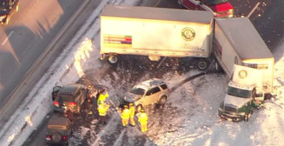
A jack-knifed semi blocked all lanes of the northbound Edens Expressway north of the Willow exit for more than an hour this morning.
The accident at one point backed up traffic to Fullerton on the Kennedy Expressway.
(Photo: WGN-TV)
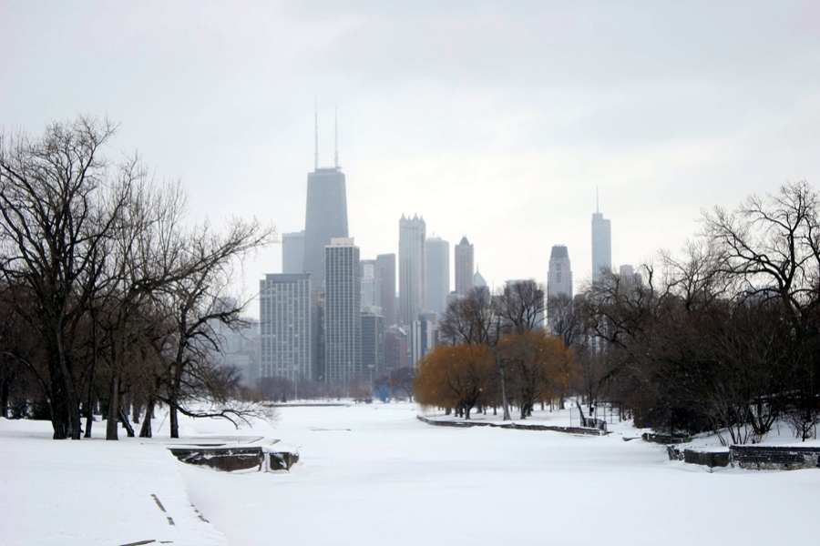
I might need to go downtown today, which will require one of the 7 bus routes or 3 El lines that pass within a kilometer of my house. And this does not bother me at all:
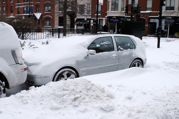
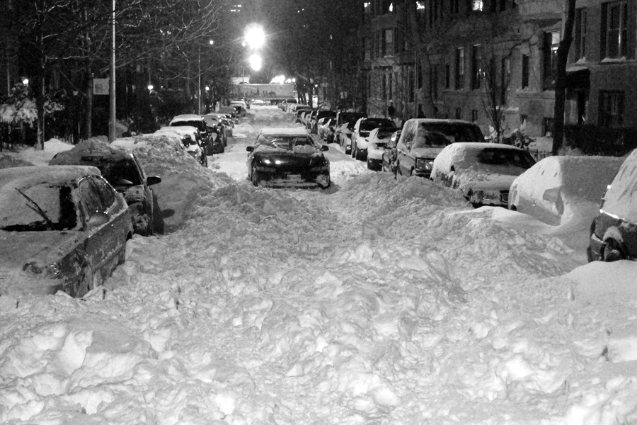
The city still hasn't plowed all the side streets, of which Chicago has almost 7,000 km, so I'll cut them some slack. Here's
Oakdale between Broadway and Clark last night:
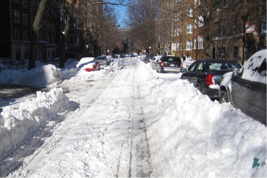
This morning, Commonwealth between Fullerton and Belden:
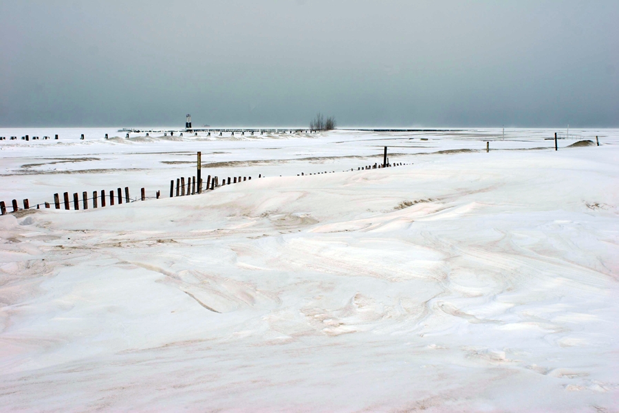
More shots from my photo safari earlier today:
At Fullerton:
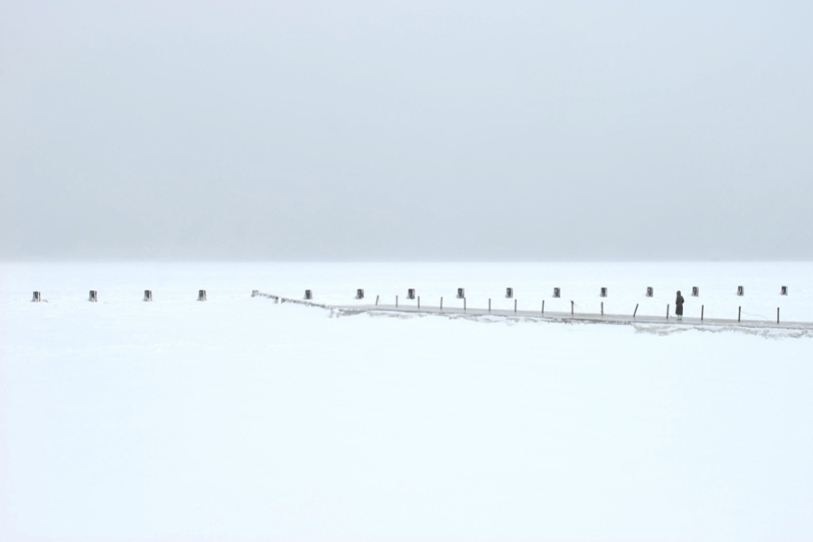
Farther down, closer to LaSalle:
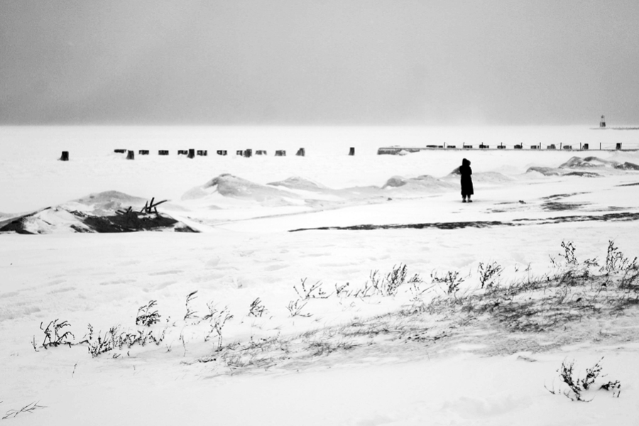
North Avenue. I processed this one a little bit to tighten up the levels; what I actually saw had much less contrast and color:
That's all for today. By tomorrow the holiday will end and I'll realize I'm a day behind in my work. And Parker will realize that he's not getting almost two hours of walks—especially because tomorrow is predicted to begin with a brisk -20°C morning.
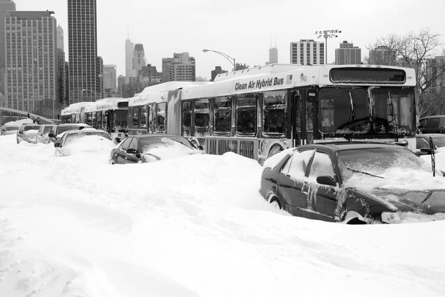
Last night hundreds of cars got stuck on Lake Shore Drive after three accidents blocked the northbound lanes between Fullerton and Belmont around 7pm. Some people were stuck in their cars as late as 3am; one friend's dad got off the Drive only around then.
Dozens of cars and buses littered the road when Parker and I went out for a 90-minute photo safari this afternoon:
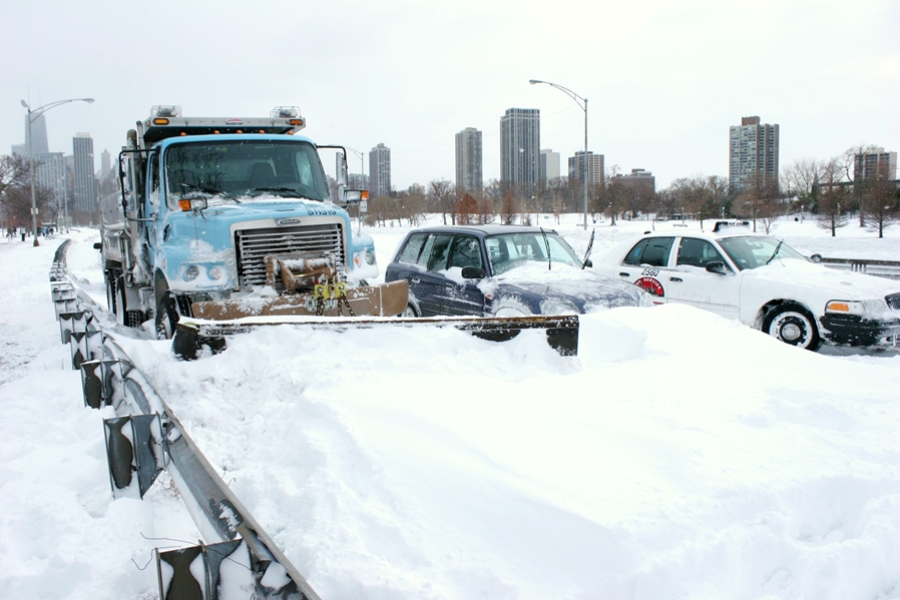
This guy also got stuck. Who's he going to call?
The snow keeps coming down here by the lake, but it's officially stopped at O'Hare. We've now had the third biggest snowfall in Chicago history: 513 mm fell over the past two days, only 70 mm short of the 1967 record.
Lest you think we're wimps here, Oak Park River Forest High School closed today for only the 5th time in its 125-year history; the last time was in 1979.
As you read this from San Francisco, or Riyadh, or Singapore, or anywhere else in the world other than the central U.S., feel the disappointment of not having the opportunity to ride this bus today:
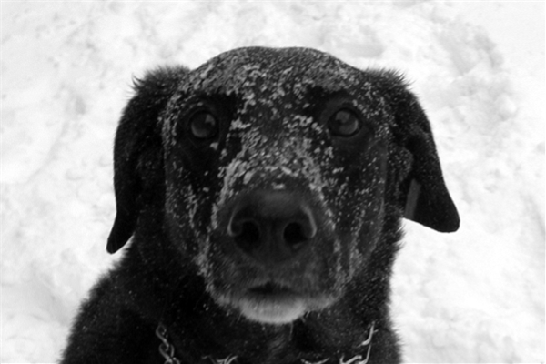
It's not horrible. Yet. The wind has calmed from its peak 82 km/h last night, and the temperature still hovers only a little below freezing, at -7°C at O'Hare and -3°C at IDTWHQ. And I'm assured it's wonderful for dogs:
As I write this, Police Superintendent Jody Weis is on the radio talking about (a) the additional snow (possibly 15 cm) expected to hit near the lake, and the -17°C cold expected tonight; and (b) the Lake Shore Drive disaster that stranded hundreds of cars for five hours or longer. "We're aware of no injuries, but hundreds of people were very inconvenienced last night."
First, a report out of Punxsutawney, Penn., that Punxsutawney Phil (the groundhog) did not see his shadow:
Punxsutawney Phil emerged from a tree stump at dawn and, unusually, did not see his shadow, signaling that spring is just around the corner, according to tradition.
"He found that there was no shadow," said Bill Deeley, president of a club that organizes Groundhog Day in the western Pennsylvania town of Punxsutawney. "So an early spring it will be."
Ah, but there's a catch:
"There is no question that Phil is capable of feeling empathy," Johnston said in an interview. "But he is absolutely incapable of error."
The rodent's predictions are "not burdened by being site-specific" and so can be sure to predict an early spring in some part of the world, Johnston added.
Who knew Phil was a lawyer? Also—wasn't there, you know, a blizzard last night?
While western Pennsylvania was spared the worst of the storm, many central and northern areas of the U.S. were hit by snow and ice that closed roads, shut down businesses, and grounded flights.
But the Punxsutawney crowd, which started arriving on Gobbler's Knob at 3 a.m., braved some of the worst weather in the last 20 years of Groundhog Day, said [Mike Johnston, vice president of the Punxsutawney Groundhog Club's Inner Circle, or board of directors].
Looking outside at the weather in Chicago, I hope Phil was thinking of the north-central U.S....
Update: The Tribune has video, and allows sharing, so:
Chicago weather conditions at 4pm: -6°C, winds northeast at 48 km/h gusting to 63 km/h, visibility 400 m in heavy, blowing snow.
Here's the corner of Belden and Clark in Lincoln Park around then:
And a little north of that, looking north:
The ParkerCam will be pointing out the window at Inner Drive Technology World Headquarters today, in case anyone wants to watch the blizzard in progress for the duration of the event:

 The weather we've worried about for a couple of days looks set to hit this afternoon:
Four days of computer forecasts of this storm, including multiple runs off 7 models, are putting the developing system on a more northerly track while generating water equivalent precipitation of around 30 mm. To convert that to snow, calculations have to be made of how snowflakes are likely to develop in the storm given a snow/water ratio predicted to be 15 to 1 Tuesday evening. [This means 450 mm of snow. —ed.]
As expected, Lake Michigan may contribute an additional 75 to 175 mm to the system in lakeside counties
The National Weather Service warns:
A BLIZZARD WARNING REMAINS IN EFFECT FROM 3 PM THIS AFTERNOON TO
3 PM CST WEDNESDAY.

* TIMING...ACCUMULATING SNOW WILL DEVELOP AROUND THE INTERSTATE 80
  CORRIDOR DURING THE EARLY TO MID AFTERNOON...SPREADING NORTH TO
  THE WISCONSIN STATE LINE BY MID TO LATE AFTERNOON. THE MOST
  SIGNIFICANT SNOW MAY COME IN A COUPLE OF WAVES...WITH THE FIRST
  WAVE LATE THIS AFTERNOON INTO EARLY THIS EVENING...FOLLOWED BY A
  SECOND WAVE OF INTENSE SNOW LATER THIS EVENING INTO THE
  OVERNIGHT. ACCUMULATING LAKE EFFECT SNOW SHOWERS WILL CONTINUE
  OVER NORTHEAST ILLINOIS WEDNESDAY MORNING...SPREADING INTO
  NORTHWEST INDIANA WEDNESDAY AFTERNOON.

* ACCUMULATIONS...SNOW WILL BE HEAVY AT TIMES WITH ACCUMULATION
  RATES OF 1 TO 2 INCHES PER HOUR LIKELY. STORM TOTAL SNOWFALL OF
  10 TO 18 INCHES IS LIKELY TOWARD ROCKFORD AND DIXON. THE
  HEAVIEST SNOWFALL TOTALS ARE LIKELY DOWNWIND OF LAKE MICHIGAN IN
  THE CHICAGO METROPOLITAN AREA INTO NORTHWEST INDIANA WHERE 12 TO
  20 INCHES OF SNOW IS LIKELY...WITH ISOLATED AMOUNTS OF AROUND 2
  FEET POSSIBLE.

* WINDS...NORTHEAST WINDS WILL INCREASE TO 20 TO 35 MPH BY LATE
  THIS AFTERNOON. WIND GUSTS UP TO 40 MPH WILL BE POSSIBLE BY
  EVENING WITH GUSTS OF 40 TO 50 MPH LIKELY TONIGHT. EVEN STRONGER
  WINDS ARE LIKELY NEAR THE IMMEDIATE LAKESHORE WITH SUSTAINED
  WINDS OF 30 TO 40 MPH WITH GUSTS BETWEEN 50 AND 60 MPH.
The Daily Parker will have updates and photos as conditions warrant.
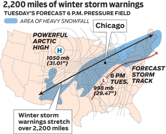
We're likely to begin February with the biggest snowfall in Chicago's recorded history:
A Blizzard Watch is in effect Tuesday afternoon through Wednesday as a strengthening low pressure system moves up the Ohio Valley. Late Tuesday afternoon steady snow and stronger winds will push into the region, starting south of I-80 and spreading north during the evening.
Snowfall rates Tuesday night could approach 50 to 80 mm per hour and when combined with sustained winds at 50-60 km/h, visibilities are will drop significantly with near whiteout conditions possible.
Snow totals of 30 to 50 cm are possible between Monday night and Wednesday afternoon with locally higher amounts. Drifting and blowing snow will make travel dangerous and possibly life threatening Tuesday night.
Lakeshore flooding is also a possibility. Waves of 3 to 5 m will crash along the Illinois side of the Lake Michigan shoreline.
Oh. Joy.